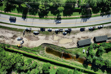
Using Drone to take stock pile measurement
In recent years, use of drones for commercial activities has increased due to government permission to fly certified and licensed drones in Florida. Civil contractors and builders have been the earliest people to adopt use of drone survey to map their project area, take pictures of their project area, and to take stock pile measurement of various materials lying in their project area.
Today, various industries that have outdoor stock which is difficult to measure and is spread over a vast area, use drone survey to map their project area, take pictures of the entire land and built area, and also make stockpile reports using data collected through drone survey and their special software.
Accurate stockpile report
Many people doubt about the accuracy of stock pile reports generated by drone survey, but they fail to understand that technology that is being used today is very accurate and supported by special software created especially for such purposes.
A few years ago, before the advent of drones, computer technologies and high-resolution cameras, gathering stock pile reports used to be a very arduous and time-consuming work that required huge manpower and lots of money for the work.
Now if you prepare your stock pile report using conventional methods and alternatively through drone survey, you will find that conventional stock pile report generated is highly inaccurate and does not incorporate much of materials lying elsewhere in the project area.
Uses very little time
Compared with all other conventional methods of making stock pile report, drone surveys offer highly accurate reports in very short period of time. While conventional methods may take weeks or even month to calculate entire stock pile, drone surveys can take accurate and clear photographs of the area covered, and come up with highly accurate data of the entire stock pile in as little as 48 hours.
Although, time taken varies from quantum of work, land covered in the project, the topography of the project land, and many other conditions,
Better insight
Unlike conventional surveys that offered only an idea about the stock pile lying in project area, drone surveys that include topographic surveys, contour maps, and photographs of stock piles, provide accurate reports of all the stock pile that you have in the project and also have better insights into the works required to be done in the project.
Help in calculating return on investment, stock mismatch and working of assets
Civil contractors, developers and industries that have outdoor projects need regular assessment of all their stock pile and other materials in the project to enable them to calculate any mismatch in stock, turnover of stock in physical with the books, calculate their return on investment on the stock and project, and also to have a fair idea about working of other assets in the project.
Getting right drone surveyor to conduct stock pile measurement
Getting a right drone operator that has the equipment and ability to conduct efficient drone surveys is most important to get accurate stock pile measurement. Florida Aerial Survey Technologies is one of the leading drone survey technology companies in Florida that has latest drones and best software technology to conduct aerial surveys in Florida and provide accurate and excellent results in a very short period of time.
Find US:
Florida Aerial Survey Technologies
Miami, Florida,USA,33101
1 239-249-5228
info@floridaaerialsurvey.com


Comments
Post a Comment